We needed coffee, so we slid Darzee into the water and Clark rowed over to the docks. Hopefully, the store wouldn't be too much of a hike up the hill. Asking directions of a woman walking there, Clark scored a ride. The woman, from a sailboat on the transient dock, said she was on her way there for beer and steaks. The sun was out and they were going to barbeque. While Clark was at the store, a large freight boat came into the bay. "Marine Link Tours" and an 800-number in big block letters was painted on its square deck house. We'd seen the same boat at Tenedos Bay on September 8th. It pushed up to a gravel road at the bank behind Rikki-tikki, dropped a loading ramp, and started carting off sacks of heavy cargo with a forklift. Passengers up top observed the goings-on. We learned that this vessel offers paying customers a unique way to see BC as it picks up and delivers cargo throughout inaccessible islands and shoreline villages. Through the binocs I could see Clark back on the dock talking to the folks at the boat. I'd noticed their windvane and apparently he had too, so he was checking it out.
As Clark started back to Rikki-tikki in Darzee, a little orange-and-black tug pulling a similarly painted barge came steaming around the corner. I wondered where he was headed with that barge and how would he control it within the confines of the bay. I called Clark on the walkie-talkie as he began to row out to Rikki. "Do you see that barge coming in? Where do you suppose he's going to go?" The radio must've garbled my question because Clark thought I was talking about the freight boat that was already situated at the dock and so he continued rowing... right out in front of the tug! From his position behind the breakwater, Clark couldn't see the tug until he'd got out in front of it. The tug pulled over to the side of the barge and powered hard in reverse to take way off the barge. I suppose he would've been doing this anyway even without my husband rowing a little plastic dinghy across his path, but I was a bit worried. Barges don't have brakes.
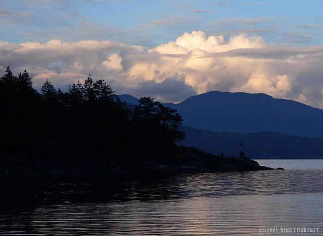
Clark started paddling much faster when he finally caught sight of the barge as it came into the small bay under its own momentum. The tug lead the barge close in past the transient dock and directly into the "anchorage" of Caesar Cove, crossing right over the spot we'd decided NOT to drop anchor. Good choice. As the barge urged its mass toward the shore behind the Marine Link boat, the tug suddenly dropped the tow cable and zoomed out of its way. The skipper churned up white water with the tug's big engine, bringing its rubber-padded bow against the flanks of the barge. He deftly nudged the hulk to lie alongside a row of steel pilings. Quite impressive. I was thankful to be parked safely away from big boats moving about. As the sun settled behind Texada Island, our view across Malaspina Strait to the BC mainland became a monochromatic composition in blue.
 Next morning, October 1st, we hoisted the Delta anchor and motored out of
Sturt Bay, destined for Smuggler Cove, a popular BC Marine Park on the
Sechelt Peninsula. We were hoping it would give Rikki good protection
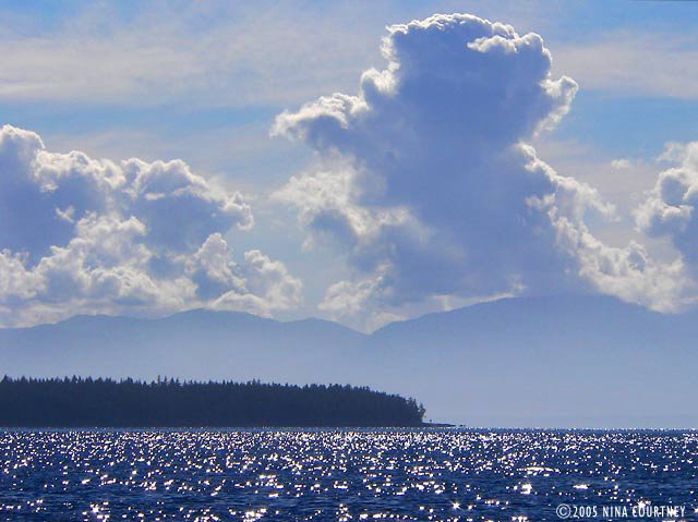
from more SE gales forecast for the 2nd, 4th, and 5th. The thunderheads
were building high and mighty over Texada and the mainland, the sun
hardening the edges and throwing glittering shards of light in our
eyes.
Next morning, October 1st, we hoisted the Delta anchor and motored out of
Sturt Bay, destined for Smuggler Cove, a popular BC Marine Park on the
Sechelt Peninsula. We were hoping it would give Rikki good protection
from more SE gales forecast for the 2nd, 4th, and 5th. The thunderheads
were building high and mighty over Texada and the mainland, the sun
hardening the edges and throwing glittering shards of light in our
eyes.
 Smuggler Cove caution: "Proceed at dead-slow and post alert bow
lookouts." Encumbered by rocks, reefs, shoals and narrow passages, this
tiny small craft stopover, we are told, can harbor dozens of cruising
boats during peak summer months. I was just relieved there was nobody
else around! Entering the cove was not difficult– we took the advice of
"Exploring the South Coast of British Columbia" authors, the
Douglasses, and avoided the hazards. The tiny first basin was too open
to the SE for our comfort, the second not much better or much bigger.
The inner basin, with its extremely narrow, shallow passage, offered
the most shelter, so we went in – very slowly – with me posted as the
alert lookout, taking photos at the same time. It was a low tide but
there was eleven feet of water, leaving seven under Rikki's keelson.
Smuggler Cove caution: "Proceed at dead-slow and post alert bow
lookouts." Encumbered by rocks, reefs, shoals and narrow passages, this
tiny small craft stopover, we are told, can harbor dozens of cruising
boats during peak summer months. I was just relieved there was nobody
else around! Entering the cove was not difficult– we took the advice of
"Exploring the South Coast of British Columbia" authors, the
Douglasses, and avoided the hazards. The tiny first basin was too open
to the SE for our comfort, the second not much better or much bigger.
The inner basin, with its extremely narrow, shallow passage, offered
the most shelter, so we went in – very slowly – with me posted as the
alert lookout, taking photos at the same time. It was a low tide but
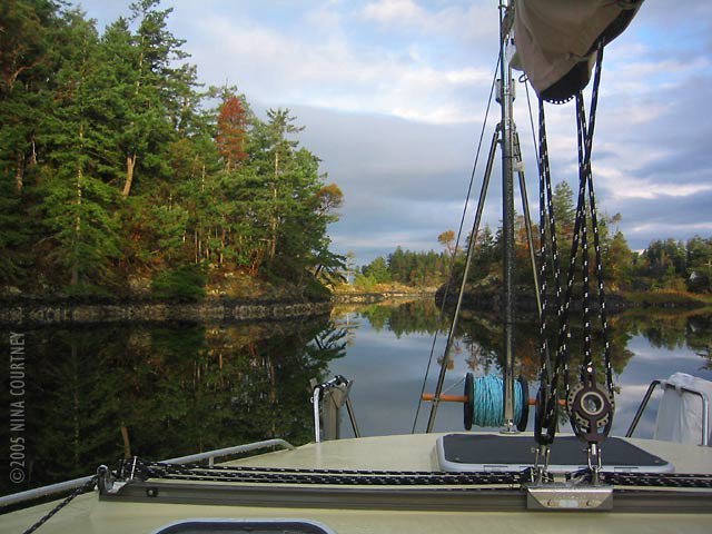
there was eleven feet of water, leaving seven under Rikki's keelson.The lagoon inside was larger than we expected and, since we had the entire place to ourselves, we anchored in the middle in eighteen feet of water. We started noticing details as we settled in. There were dozens of orange rings drilled into the rock along rocky shore for use as stern line anchor points. A lot more rings revealed themselves as we rowed Darzee along the edges of the two outer basins, many of these seemed to be placed much too close to the numerous shoal areas. We were left questioning whether anyone would actually use them. We couldn't imagine the Cove harboring as many boats as there were rings! While we enjoyed hanging on anchor there for six nights, only three boats ventured into the inner basin and all three turned right around and went back out. Only four sailboats anchored in the outer basins overnight, usually only one at a time, and they were always out of our view except for the tip of their masts. We were secluded in our watery haven, visited only by an otter and two pair of loons, the resident belted kingfishers, a large pileated woodpecker, an osprey, the usual fleet of common mergansers and flocks of lovely varied thrushes.
 We heard voices. At the head of the lagoon, a group of hikers stopped
to read a marker. There was a trail! Finally, a place to get off the
boat and walk. But first things first, before the gale hit, we put the
motor on Darzee and motored over to Secret Cove, a mile to the north.
We hoped to find a grocery store for eggs and cream, but the marinas
looked shuttered for the season. At the Jolly Roger, a man on the docks
was carrying boat cushions up to his van, preparing to leave his
sailboat closed up for winter. We asked if there was a grocery. He said
the closest was five miles away in Halfmoon Bay. Jans offered to drive
us there, so we hopped into the van with the cushions and sailbags. The
Halfmoon Bay Grocery is a historic artifact of a building, whose owner
is from Pleasanton, CA. We've met numerous folks from the States,
enjoying a quieter life here in BC. We bought a bottle of bubbly to
celebrate our anniversary.
We heard voices. At the head of the lagoon, a group of hikers stopped
to read a marker. There was a trail! Finally, a place to get off the
boat and walk. But first things first, before the gale hit, we put the
motor on Darzee and motored over to Secret Cove, a mile to the north.
We hoped to find a grocery store for eggs and cream, but the marinas
looked shuttered for the season. At the Jolly Roger, a man on the docks
was carrying boat cushions up to his van, preparing to leave his
sailboat closed up for winter. We asked if there was a grocery. He said
the closest was five miles away in Halfmoon Bay. Jans offered to drive
us there, so we hopped into the van with the cushions and sailbags. The
Halfmoon Bay Grocery is a historic artifact of a building, whose owner
is from Pleasanton, CA. We've met numerous folks from the States,
enjoying a quieter life here in BC. We bought a bottle of bubbly to
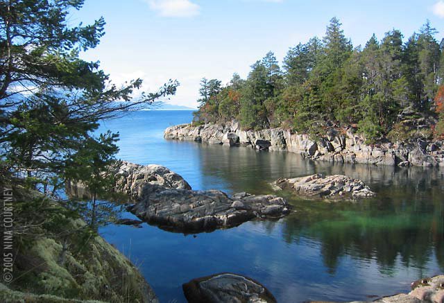
celebrate our anniversary.Back at the Jolly Roger, we made a few calls to home on the pay phone. It rained a lot at Smuggler Cove, especially on the 6th. The winds, when they arrived, went right over us through the top of the trees, leaving us unflustered. We walked the mossy, bouldered trails along the point to overlook Welcome Passage, Malaspina Strait, and Thormaby Island with its sandy beaches. This photo of the entrance to Smuggler Cove was taken at high tide, when the shoals and rocks are most hidden. Notice the blue sky and flat water? Environment Canada forecast gale winds across the Strait of Georgia this day, so we stayed put. They gave us a lovely day to stretch our legs while enjoying the sun.
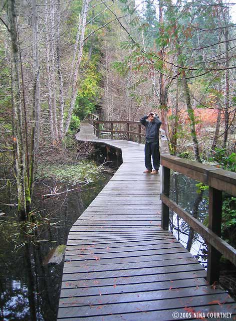
 Over the next few days, we twice walked the longer trail, which had a
boardwalk over wetlands and passed through dense forest, even extending
our walk out toward Fishermans Cove along the road. We never got there
but we got in some good exercise. The bog trail was truly wonderful. It
went through several habitats and environments and offered sightings of
winter wren (I always pack the small binocs now) and some red mushrooms
with white spots. A pair of hikers with whom we got to chatting told us
what they were, but we've forgotten.
Over the next few days, we twice walked the longer trail, which had a
boardwalk over wetlands and passed through dense forest, even extending
our walk out toward Fishermans Cove along the road. We never got there
but we got in some good exercise. The bog trail was truly wonderful. It
went through several habitats and environments and offered sightings of
winter wren (I always pack the small binocs now) and some red mushrooms
with white spots. A pair of hikers with whom we got to chatting told us
what they were, but we've forgotten.
 As we arrived at the road, a group of school children was trundling out
of cars and vans with their teachers for an excursion down the trail.
Smuggler Cove was once the home of "King of the Smugglers". It was once
profitable to assist Chinese laborers across the border into the US.
The trail markers also tell of the local Indians and how they used the
plants and resources of the area to live. It's a good place for a field
trip. We should've tagged along and learned even more about the Cove
and its history.
As we arrived at the road, a group of school children was trundling out
of cars and vans with their teachers for an excursion down the trail.
Smuggler Cove was once the home of "King of the Smugglers". It was once
profitable to assist Chinese laborers across the border into the US.
The trail markers also tell of the local Indians and how they used the
plants and resources of the area to live. It's a good place for a field
trip. We should've tagged along and learned even more about the Cove
and its history.
 We motored over to Secret Cove again, for a more thorough exploration
of its shores– and five gallons of water. We went up and down each arm
of the large harbor, gawking at some impressive homes, one of which set
Clark's urge to build into high gear. It was a particularly
well-balanced neo-craftsman style, situated in the trees with a private
dock. I agreed that the design was both impressive and
comfortable-looking. We gazed at it for many minutes. Another, on a
picturesque point just across from Secret Cove Marina, was in the final
stages of completion. It looked as though it could be an Architectural
Digest feature home, with its contemporary lines, expansive angular
rock and slate entry, wide overhangs and large windows. A bit too
commercial-looking for our taste, but admirable.
We motored over to Secret Cove again, for a more thorough exploration
of its shores– and five gallons of water. We went up and down each arm
of the large harbor, gawking at some impressive homes, one of which set
Clark's urge to build into high gear. It was a particularly
well-balanced neo-craftsman style, situated in the trees with a private
dock. I agreed that the design was both impressive and
comfortable-looking. We gazed at it for many minutes. Another, on a
picturesque point just across from Secret Cove Marina, was in the final
stages of completion. It looked as though it could be an Architectural
Digest feature home, with its contemporary lines, expansive angular
rock and slate entry, wide overhangs and large windows. A bit too
commercial-looking for our taste, but admirable.We listened several times a day to the marine forecast. The day we chose to leave for Silva Bay, about thirty miles across Georgia Strait on Gabriola Island, the voices crackling over the VHF predicted winds of less than ten knots. We experienced winds more in the 15-18 knot range. The "automated reports" claimed the "combined wind wave and swell height" at Halibut Bank to be "zero decimal three meters". As we passed by The Bank, we were splashing though waves obviously more than a meter high, not counting the SE swell! It was bumpy! We rolled out the jib and fell off the wind to pick up some speed, which we could do because the military activity zone "Whiskey Golf" was not active that day. It was "clear for transit". Crossing on this angle meant that when we reached Entrance Island, we'd have to motor directly into the wind for the last couple of miles. But, hey, we did that all the way up the West Coast, so nothing new there. Silva Bay was more busy and open to weather than we had become accustomed to but we anchored in front of Page's Marina to wait for another SE gale to pass over. We'd also have to time our transit through the rapids at Gabriola Passage, out of the Strait of Georgia and into Trincomali Channel. We were back in the Gulf Islands.
Fair winds, Clark & Nina
No comments:
Post a Comment